「板橋」
Do you know about Japanese place names? The name Itabashi comes from the name of the bridge that crosses the Shakujii River, where the former Nakasendo Road intersects. At 4T-AMKY, Teachers and Students write about Japanese culture, food, history, many spots to visit, and other stuff. Enjoy reading and knowing about deeper Japanese culture!
Itabashi
Itabashi-Shuku on Nakasendo Road
I walked around Itabashi-Shuku, which is said to be the area where the path of Nakasendo, one of the five highways developed in the Edo era (1603-1867), remains as it was. Shukuba-machi (inn towns) extend along the old Nakasendo Road from near JR Itabashi Station to Hiraoshuku, Nakashuku, and Kamishuku, stretching about 1.7 km.

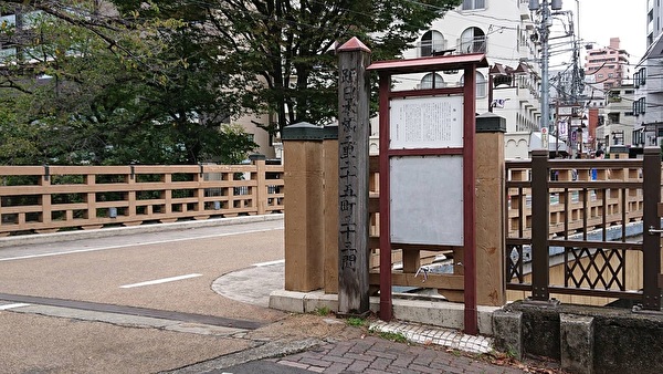
The only buildings remaining from that time are temples, but there were explanatory boards for each of the famous and historical sites. It was fun to read them and walk around looking at the scenery and thinking about the distant past.

Itabashi-Shuku is the first inn town along the Nakasendo Road, counting from Nihonbashi. Along with Shinagawa-Shuku (Shinagawa Ward) on the Tokaido Road, Senju-Shuku (Adachi Ward) on the Oshu and Nikko Roads, and Naito-Shinjuku (Shinjuku Ward) on the Koshu Road, it is one of the “Edo Shi (Four) Shuku” located at the entrance and exit of Edo (present-day Tokyo).
The Okido at the entrance to Kamishuku is the boundary with Edo, and inside the Okido is the Funai (Edo) area. It is said that criminals who were sentenced to Edo exile could live a normal life once they left this Okido. Currently, nothing remains. It reminded me of Yotsuya Okido. And I was once again convinced of the meaning and role of the Okido in the city of Edo.
Itabashi (literally means “bridge of boards”), which is the origin of the name of the place of Itabashi, was located between Nakashuku and Kamishuku. This bridge crosses where the old Nakasendo Road and the Shakujii River intersect.

According to the explanatory board, the bridge in the Edo era was a drum-shaped wooden bridge. (It is truly a bridge of boards.) It was restored at least twice during the Edo era. Later, it was replaced in 1920, and in 1932, it was replaced with a concrete bridge to accommodate the spread of automobiles. In 1958, the Shakujii River overflowed due to a typhoon, causing severe damage in Itabashi Ward. As a result, the river was repaired, and in 1972, the bridge was replaced with the current one.
The Shakujii River used to make a big bend at the point of this bridge, but it was straightened to prevent flooding. And the remaining old stream channel is now a park. It reminded me of Otonashi Water Park in Kita Ward, where the old channel of the Shakujii River was turned into a park.

By actually walking around Itabashi-shuku, looking at Itabashi and the Shakujii River, and learning about its origins, I realized the preciousness of the wisdom, technology, and labor of our ancestors to protect the town and its people from disasters. It also made me feel grateful to be able to live safely in the midst of abundant nature.
The name Itabashi is said to be already visible in old books written from the Kamakura to Muromachi eras, and because of this bridge, it became the name of an inn in the Edo era, the name of a town in 1889, and in 1932, it was adopted as the name of the ward and became Itabashi Ward.
「板橋」
中山道の板橋宿
江戸時代に五街道の一つとして整備された中山道の板橋宿辺りは、中山道の道筋がそのまま残っている、というので歩いてみました。宿場町は、JR板橋駅付近から、平尾宿、仲宿、上宿と約1.7㎞に渡って街道沿いに長く続いています。
当時の建物はお寺ぐらいしか残っていませんが、名所・旧跡にはそれぞれ説明板がありました。それらを読んで辺りの景色を眺め、遠い昔に思いを巡らせながら歩くのは楽しいものでした。
板橋宿は、日本橋から数えて最初の中山道の宿場町です。東海道の品川宿(品川区)、奥州街道・日光街道の千住宿(足立区)、甲州街道の内藤新宿(新宿区)と共に、江戸の出入り口に位置する「江戸四宿」(えどししゅく)の一つです。
上宿の入り口にある大木戸が江戸との境界線となっていて、その内側が府内(江戸)です。江戸処払いの刑を受けた罪人はこの大木戸を出れば普通に暮らせたのだそうです。現在は何も残っていません。思わず四谷大木戸を思い出しました。そして江戸の街における大木戸の意味や役割が改めてよくわかりました。
板橋の地名の由来ともなった板橋は、仲宿と上宿の間にありました。旧中山道と石神井川が交差する場所にかかる橋です。
説明版によると、江戸時代の橋は太鼓状の木製の橋でした。(まさに板の橋です)江戸時代に少なくとも2度修復が行われました。その後、1920年(大正9年)に架け替えられ、1932年(昭和7年)には自動車の普及に対応するためコンクリートの橋に架け替えられました。1958年(昭和33年)の台風で石神井川が氾濫し、板橋区内に大きな被害をもたらしました。それを契機に河川改修が行われ、1972年(昭和47年)に現在の橋に架け替えられた、ということです。
石神井川はこの橋の地点で大きく屈折していましたが、氾濫を防止するためにまっすぐの河川の流れとされました。そして残った旧流路は公園となりました。思わず、北区で石神井川の旧流路を公園にした音無親水公園を思い出しました。
実際に板橋宿を歩き、板橋や石神井川を眺め、その成り立ちを知ることによって、街や人々を災害から守るための先人の知恵や技術や労力の尊さに気づかされました。そして、豊かな自然の中で安心して暮らせることへの感謝の気持ちが沸き起こりました。
板橋の名称は、すでに鎌倉から室町時代にかけて書かれた古書の中に見えるそうですが、この橋があるために、江戸時代になると宿場の名となり、1889年(明治22年)には町名となり、1932年(昭和7年)には区の名称にも採用され板橋区となったということです。
Ikuyo.K.


