「お茶の水」
Do you know about Japanese place names? The name of Ochanomizu is a place name originating from the Edo era. At 4T-AMKY, Teachers and Students write about Japanese culture, food, history, many spots to visit, and other stuff. Enjoy reading and knowing about deeper Japanese culture!
Ochanomizu
Origin
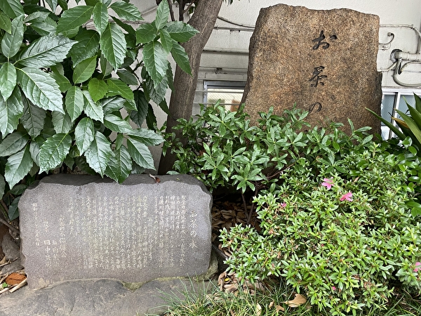
I learned from a guidebook that there is a “Monument of Ochanomizu” at the foot of Ochanomizu Bridge, so I went there.
After exiting the JR Ochanomizu Bridge exit and crossing the scramble intersection, the “Monument of Ochanomizu” was standing right next to the police box. Next to it was a monument describing the origin of the name of Ochanomizu and a small shishiodoshi. (Shishiodoshi is a device designed for making noise and comprised of a bamboo pipe and running water for scaring birds and animals from gardens.)

I went there for the “Monument of Ochanomizu” and found it easily. But it was so small and quiet that I would have passed by it without noticing it if I had not known it was there.
Ochanomizu is the name of an area extending from Yushima, in Bunkyo Ward, in the north to Kanda-Surugadai, in Chiyoda Ward, in the south. It is on a plateau, with the Kanda River flowing through an excavation that runs east-west through the center of the plateau. Before the excavation was built, it was a continuous plateau called Kanda-Yama (Mountain).
During the reign of the second shogun, Hidetada Tokugawa (1579-1632), Kanda-Yama was cut through to divide it into Yushima-dai and Surugadai. And an artificial valley was excavated in present-day Ochanomizu, changing the channel of the old Hirakawa River to the Kanda River. On the south side of this plateau was Edo Castle and the city of Edo. To avoid flood damage and to strengthen the outer moat, a ditch was made in the east-west direction of Kanda-Yama, creating the valley-like topography that we see today.
At that time, there was a Zen temple called Korinji at the foot of Kanda-Yama. It is said that fresh water gushed out from the precincts of Korinji Temple during the cutting down Kanda-Yama in order to dig the outer moat. When it was presented to Shogun Hidetada on his way back from falconry, it was used for tea. And he was so pleased with it that it became a purveyor to the Tokugawa family. This is why the temple came to be called “Ochanomizu Korinji Temple,” and eventually the area around it came to be called “Ochanomizu.”
Later, when the Kanda River was expanded, the spring at Korinji was included in the riverbed and disappeared. Korinji Temple also moved to its current location at Mukogaoka, Bunkyo Ward. Therefore, there are no remnants of the spring water today. What remained was the place name Ochanomizu.
「お茶の水」
由来
お茶の水橋のたもとに「お茶の水の碑」がある、とガイドブックで知ったので行ってみました。
JR御茶ノ水橋口から出て、スクランブル交差点を渡ると交番のすぐ脇に、「お茶の水の碑」が立っていました。隣にお茶の水の地名の由来を記した碑と、小さなししおどしもありました。(ししおどしとは、竹筒と流水で音を出し、庭の鳥や動物を追い払うための装置です)
「お茶の水の碑」を目指して行ったのですぐわかりました。しかし、知らなければ気づかぬままに通り過ぎてしまいそうなほど、それらは小さくひっそりと立っていました。
お茶の水は、北は文京区湯島から南は千代田区神田駿河台に至る一帯の地名です。台地の上にあって、その中央部を東西に走る掘割に神田川が流れています。掘割が作られる以前は神田山と呼ばれる一続きの台地だったそうです。
第2代将軍・徳川秀忠(1579~1632年)の時代に、神田山を切り通して湯島台と駿河台とに分けました。そして、現在のお茶の水に人工の谷を開削し、旧・平川の流路を変えて神田川としました。この台地の南側に江戸城があり、江戸の街がありました。水害を避けるために、そして外堀を強化するために、神田山の東西方向に掘割が作られ、現在のような渓谷風の地形が形成されたというわけです。
当時、神田山の麓に高林寺という禅寺がありました。外堀を掘るための神田山切り崩し中に、高林寺の境内から清水が湧き出したそうです。それを、鷹狩りの帰途にあった将軍秀忠に差し出したところ、お茶に用いられました。そして、大変気に入られ、徳川家御用達となりました。それでこの寺を「お茶の水高林寺」と呼ぶようになり、やがてこの周辺を「お茶の水」と言うようになったということです。
その後、神田川が拡張された際に、高林寺の湧水は河川敷に含まれ消えてしまいました。高林寺も現在地の文京区向丘に移転しました。そのため、現在は湧き水の名残はありません。後に残ったのはお茶の水という地名でした。
Ikuyo.K.


